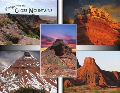
Location from Fairview, Oklahoma:
6 Miles North of Fairview, then 5.5 Miles West on US Hwy 412. Hours: Dawn to Dusk, 365 Days (including holidays). Park Information: 580-227-2512. Hiking * Picnic Areas * Flora, Fauna, Wildlife, Geological. Please Note: No overnight accommodations. Download the Park Brochure: Here. |
|
Hiking at Gloss Mountain State Park:
If you are into hiking, climbing, and exploring, a trail and stairway system is in place at Gloss Mountain State Park. You may hike from the lower parking lot and picnic area to the top of Cathedral Mountain. From the south rim of Cathedral Mountain, you can follow the trail north to view Lone Peak and observe the scenic view in every direction. Cathedral Mountain Trail from the starting point to the north rim and return is 1.2 miles in length.
Points of Interest: Cheyenne Valley and the Gloss Mountain range to the west, the Cimarron River to the north, working oil pump jacks, numerous ponds, rock formations, wildlife, and a view that never ends. Points of interest are noted on a map in the Gloss Mountain State Park brochure. Brochures are available along Cathedral Mountain Trail as well as in the kiosk at the front park gate and near the restroom facility.
Basic Information: The Gloss Mountains consist of buttes which rise from 50 to 175 feet above the valley floor. The northern most butte, named Lone Peak, is the highest.
Sparkly "Stuff":
Whether you’re hiking or driving by on the highway, you’ll notice at various times that broken mirrors or glass seems to be reflecting light back at you. Actually, it is Selenite or what is often referred to as Isinglass that you are seeing. Three things cause you to see the Selenite better at certain times: rain, clouds, and the sun. The rain tends to wash the red dust or dirt off, and the clouds in combination with the sun seem to create spot light effects. If you take photos, you will notice how the clouds cause all types of effects. Sorry, but we haven’t figured any method for photographing the mountains and capturing the sparkly stuff. By the way, “souvenir” Selenite is available at two baskets adjoining trails in Gloss Mountain State Park. We ask that you leave everything else untouched for the enjoyment of future visitors.
Geology:
There are two time periods of formation represented at the Gloss Mountain site. The first is the Quaternary period which is the last one million years of history. This period marks the formation of Pleistocene terraces along major streams with Holocene or recent alluvium along the valleys, having sand, gravel, silt, clay and volcanic ash up to 100 feet thick or more. Thin veneers of flood plain deposits are on the southwest sides of the river.
The second period is the Permian which was 270 - 230 million years ago. This period is indicated by red sandstone and shale 1000 - 4500 feet thick with gypsum on the outcroppings. Permian redbuds are irregularly slumped due to the solution of the underlying salt and gypsum beds. The Permian redbeds are subdivided into the Cimarronian Series (2850 feet) at the base, overlain by the Custerian Series (400 feet, top eroded). Flowerpot shale (180 - 430 feet) is found at this area. It consists mainly of red-brown illitic-chloritic shale, which is gradational southward into the upper Duncan Sandstone and lower Chickasha Formation. Thick salt units are also found widespread in the subsurface.
Major Streams of the area were initiated as southeast flowing tributaries of the Mississippi River fed by glaciers melting in the Rockies. Present day streams in the area form extensive flood plains rather than cut deeper channels.
Minerals found at the site are salt, copper, gypsum, sand, gravel and spar.
White Rings - Gypsum:
Many people observe white rings on the side of exposed mountains and on the red beds in front of many mountains. What are they, and what causes them? Gypsum is leaching out of the ground and is actually what causes the white ring. Usually, they are more visible after rainfall or when it is extremely damp.


